Rugged GPS Compass Smartwatch for Every Adventure
It is very important to have a reliable navigation tool when exploring remote mountain trails or managing field operations in tough conditions. In a wrist-worn device made for harsh conditions, a rugged GPS compass smartwatch offers accurate compass orientation, multi-constellation satellite tracking, and military-grade durability. These smartwatches help people who work in logistics, field engineering, outdoor tourism, and search-and-rescue by showing their location in real time, monitoring their environment, and communicating in an emergency. If purchasing managers and distributors are looking at wearable tech for tough jobs, knowing the technical specs and operating benefits of these devices is important for making smart buying choices that improve safety and efficiency.
Understanding Rugged GPS Compass Smartwatches
What Defines a Rugged GPS Compass Smartwatch?
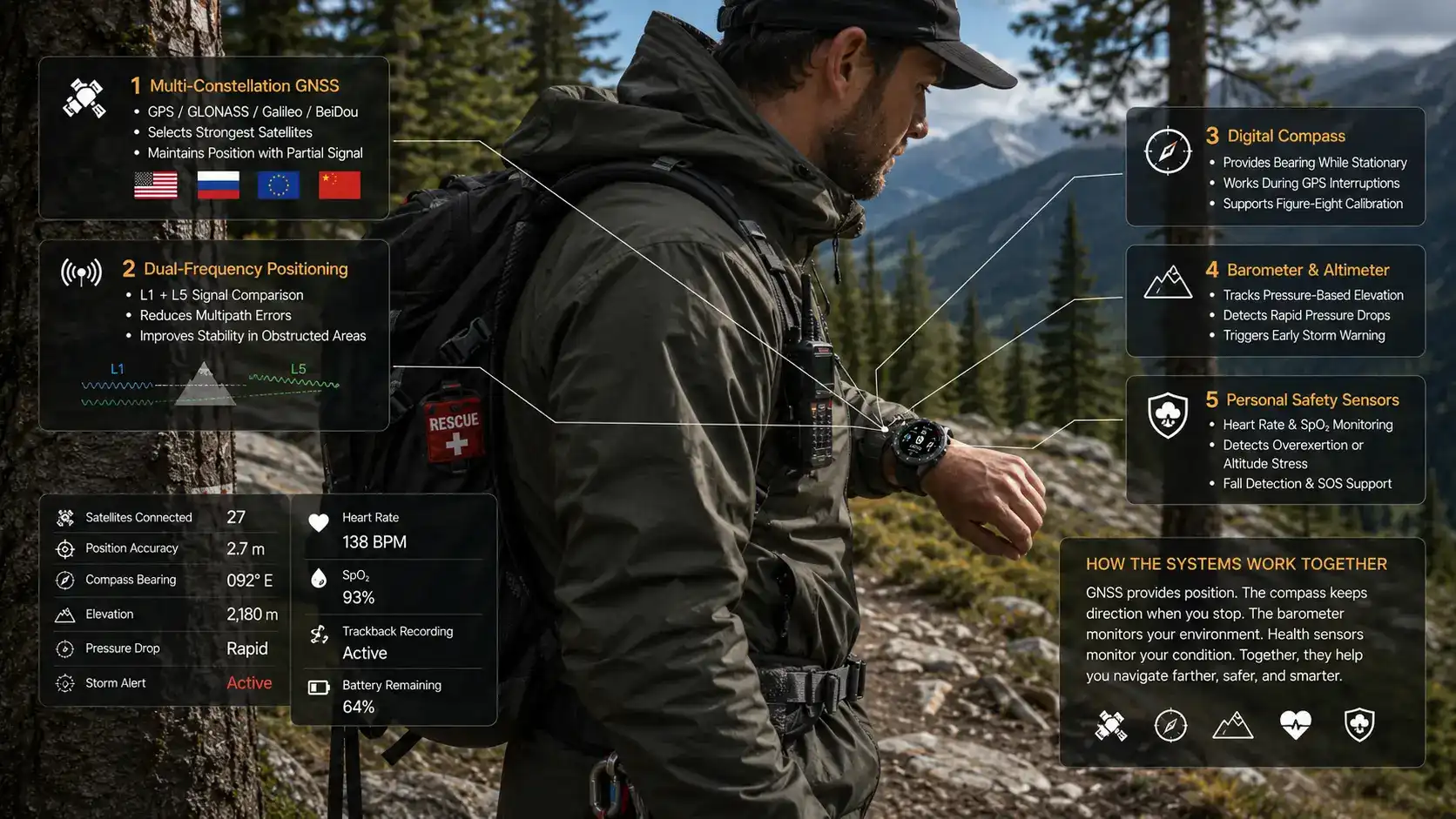
Wearable tech made for the outdoors is very different from fitness trackers for regular people. A strong navigation smartwatch has multiple GPS receivers, an electronic compass sensor, and a stronger build so it can work reliably even when other devices don't. Using GPS, GLONASS, Galileo, and BeiDou all together gives you a precise location even in dense forests or urban canyons where signals are often blocked. The digital compass, on the other hand, uses three-axis magnetometers to give bearing information even when there is no satellite connection. This is very important for navigation when there is no signal or when working inside.
These gadgets meet very strict standards for longevity. The MIL-STD-810H approval proves that the product can withstand shocks, temperatures between -20°C and +60°C, and performance at elevations higher than 10,000 meters. The testing procedures mimic the effects of drops, vibrations, and sudden changes in temperature that field equipment often faces. Water resistance of 100 meters (10 ATM) according to ISO 22810 standards lets you use it underwater for water activities, and IP67-rated sealing keeps dust and sand out when you use it in the desert or on a construction site.
Core Technical Features and Professional Capabilities
Modern navigation smartwatches have more than just sensors for positioning. Barometric altimeters use changes in atmospheric pressure to measure changes in elevation with a one-meter accuracy. They are very useful for climbing and flying. The barometer part looks at changes in pressure to predict changes in the weather. When pressure drops quickly, it means that a frontal system is coming up. This sets off storm alerts. PPG sensors in heart rate monitors let you keep track of your body while you're working out, and pulse oximetry checks the level of oxygen in your blood to find hypoxia at high elevations.
Battery design takes into account the power needs of tracking satellites all the time. High-density lithium-ion cells with a 400mAh+ capacity allow for normal use for 5–10 days, or up to weeks if expedition modes are turned on, which slow down screen refresh rates and limit sensor polling intervals. Enterprise mobile device management (MDM) platforms can work with the Android operating system. This means that IT departments can update firmware, set up security policies, and add data streams to asset tracking dashboards.
Reading ease and power use are both taken into account by display technology. The 1.52-inch IPS screen has a resolution of 280x320 pixels and can be seen in direct sunlight. The fabric strap is light and comfortable to wear for long periods of time. Fiber-reinforced polymer materials keep the structure of the plastic case strong while reducing its weight compared to metal housings. BLE and ANT+ are two types of connectivity that let you sync your data wirelessly with smartphones and external sensors without draining the battery too quickly in a rugged GPS compass smartwatch.
Comparing Top Rugged GPS Compass Smartwatches in 2026
Evaluating Leading Models for Professional Procurement
When looking at devices for use in businesses, a number of makers regularly produce ones that work well. The Instinct and Tactix lines from Garmin have military-specific features like being able to work with night vision goggles (NVGs) and showing both latitude and longitude and MGRS grid coordinates. Suunto's traverse models focus on route planning with features like breadcrumb trails and GPS track logging that can store more than 100 hours of data. The Pro Trek line from Casio includes tide graphs and moon phase maps that are useful for the fishing and marine industries.
The depth of features makes the difference between consumer- and professional-grade units clear. While consumer models focus on fitness tracking and smartphone alerts, rugged GPS compass smartwatches put more emphasis on accurate navigation, reliable environmental sensors, and longer periods of self-operation. With TracBack routing, return paths are instantly generated from current places to starting points. This means that waypoints don't have to be entered by hand during emergency evacuations. Similarly, storm alert systems that look at barometric pressure trends let people know ahead of time when dangerous weather is going to happen.
When buying in bulk, the price range for each unit is usually between



Rugged GPS Compass Smartwatch for Every Adventure
It is very important to have a reliable navigation tool when exploring remote mountain trails or managing field operations in tough conditions. In a wrist-worn device made for harsh conditions, a rugged GPS compass smartwatch offers accurate compass orientation, multi-constellation satellite tracking, and military-grade durability. These smartwatches help people who work in logistics, field engineering, outdoor tourism, and search-and-rescue by showing their location in real time, monitoring their environment, and communicating in an emergency. If purchasing managers and distributors are looking at wearable tech for tough jobs, knowing the technical specs and operating benefits of these devices is important for making smart buying choices that improve safety and efficiency.
Understanding Rugged GPS Compass Smartwatches
What Defines a Rugged GPS Compass Smartwatch?
Wearable tech made for the outdoors is very different from fitness trackers for regular people. A strong navigation smartwatch has multiple GPS receivers, an electronic compass sensor, and a stronger build so it can work reliably even when other devices don't. Using GPS, GLONASS, Galileo, and BeiDou all together gives you a precise location even in dense forests or urban canyons where signals are often blocked. The digital compass, on the other hand, uses three-axis magnetometers to give bearing information even when there is no satellite connection. This is very important for navigation when there is no signal or when working inside.
These gadgets meet very strict standards for longevity. The MIL-STD-810H approval proves that the product can withstand shocks, temperatures between -20°C and +60°C, and performance at elevations higher than 10,000 meters. The testing procedures mimic the effects of drops, vibrations, and sudden changes in temperature that field equipment often faces. Water resistance of 100 meters (10 ATM) according to ISO 22810 standards lets you use it underwater for water activities, and IP67-rated sealing keeps dust and sand out when you use it in the desert or on a construction site.
Core Technical Features and Professional Capabilities
Modern navigation smartwatches have more than just sensors for positioning. Barometric altimeters use changes in atmospheric pressure to measure changes in elevation with a one-meter accuracy. They are very useful for climbing and flying. The barometer part looks at changes in pressure to predict changes in the weather. When pressure drops quickly, it means that a frontal system is coming up. This sets off storm alerts. PPG sensors in heart rate monitors let you keep track of your body while you're working out, and pulse oximetry checks the level of oxygen in your blood to find hypoxia at high elevations.
Battery design takes into account the power needs of tracking satellites all the time. High-density lithium-ion cells with a 400mAh+ capacity allow for normal use for 5–10 days, or up to weeks if expedition modes are turned on, which slow down screen refresh rates and limit sensor polling intervals. Enterprise mobile device management (MDM) platforms can work with the Android operating system. This means that IT departments can update firmware, set up security policies, and add data streams to asset tracking dashboards.
Reading ease and power use are both taken into account by display technology. The 1.52-inch IPS screen has a resolution of 280x320 pixels and can be seen in direct sunlight. The fabric strap is light and comfortable to wear for long periods of time. Fiber-reinforced polymer materials keep the structure of the plastic case strong while reducing its weight compared to metal housings. BLE and ANT+ are two types of connectivity that let you sync your data wirelessly with smartphones and external sensors without draining the battery too quickly in a rugged GPS compass smartwatch.
Comparing Top Rugged GPS Compass Smartwatches in 2026
Evaluating Leading Models for Professional Procurement
When looking at devices for use in businesses, a number of makers regularly produce ones that work well. The Instinct and Tactix lines from Garmin have military-specific features like being able to work with night vision goggles (NVGs) and showing both latitude and longitude and MGRS grid coordinates. Suunto's traverse models focus on route planning with features like breadcrumb trails and GPS track logging that can store more than 100 hours of data. The Pro Trek line from Casio includes tide graphs and moon phase maps that are useful for the fishing and marine industries.
The depth of features makes the difference between consumer- and professional-grade units clear. While consumer models focus on fitness tracking and smartphone alerts, rugged GPS compass smartwatches put more emphasis on accurate navigation, reliable environmental sensors, and longer periods of self-operation. With TracBack routing, return paths are instantly generated from current places to starting points. This means that waypoints don't have to be entered by hand during emergency evacuations. Similarly, storm alert systems that look at barometric pressure trends let people know ahead of time when dangerous weather is going to happen.
When buying in bulk, the price range for each unit is usually between $180 and $350, but this depends on the features and level of customization needed. When you buy more than 100 units, you can often get discounts ranging from 15% to 25%. Manufacturer warranties range from standard two-year coverage to enterprise-level three-year protection that includes faster replacement services. When figuring out the total cost of ownership, you have to include the costs of new straps, protective screen covers, and charge stations for teams of field workers.
Supplier Reliability and Partnership Considerations
When choosing the right providers, you need to look at more than just the product specs. Technical support resources, such as pre-deployment configuration help and troubleshooting documentation, can be accessed through partnerships with manufacturers. Low minimum order quantities (MOQ) from vendors allow for phased rollouts for pilot testing before committing to large-scale procurement. When equipment breaks down in the field, quick replenishment processes are important. This makes store availability and shipping speed very important evaluation factors.
Quality assurance goes beyond just delivering the goods. Long-term procurement satisfaction is affected by how warranty claims are handled, how many defects are reported through industry channels, and how quickly service is provided after the sale. Distributors that support OEM customization make it possible for businesses to use private labeling, custom software setups, or sensor calibrations that are just right for their needs, including solutions for watches with compass and GPS. These features are especially useful for businesses that are making their own tracking systems or making sure that their brand is consistent across all of their equipment rentals.
How Rugged GPS Compass Smartwatches Solve Key Challenges in Outdoor and Industrial Environments?
Overcoming GPS Signal Interference and Compass Accuracy Issues
Navigation is always hard when the ground is complicated. Satellites can't see through canyon walls, dense tree cover, and groups of buildings, so single-system GPS receivers lose their position locks. Multi-constellation antennas get around this problem by connecting to 30 or more satellites at once instead of the 4–6 that are needed for position fixes. If there are clouds over the GPS satellites, the device instantly changes to GLONASS, Galileo, or BeiDou satellites to keep tracking.
Magnetic disturbance from electrical equipment, metal buildings, and rocks with a lot of iron can make a compass less accurate. Local distortions are taken into account by three-axis magnetometer calibration methods that ask users to move their wrists in a figure-eight pattern to map the magnetic field before setting true north references. The electronic compass works without GPS, so it can tell you where you are going even when satellite signals aren't available, like inside buildings or underground facilities.
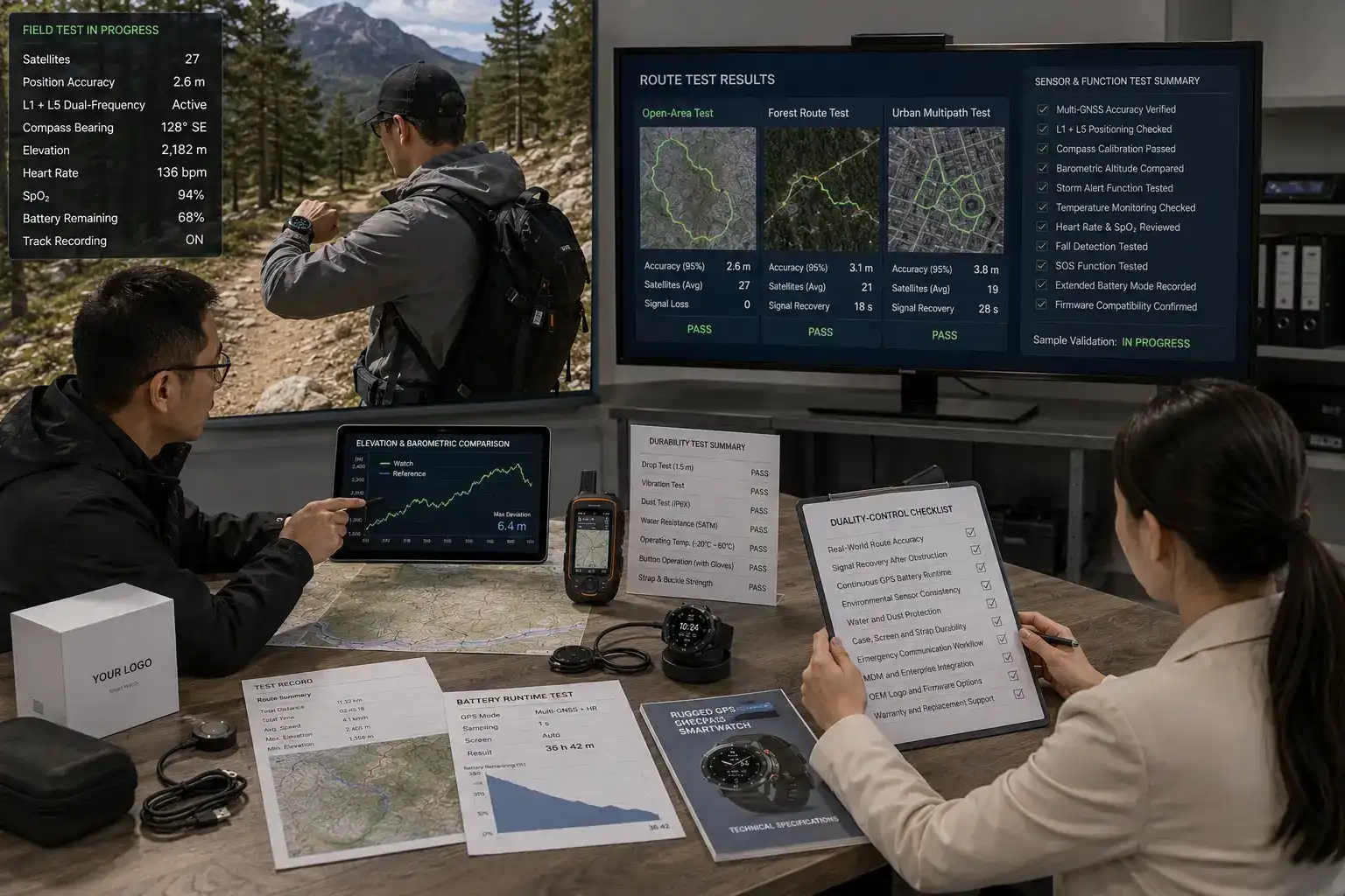
These days' chipsets use the L1 and L5 frequency bands to get rid of multipath errors that happen when signals bounce off surfaces. The L5 band, which operates at 1176.45 MHz, is less likely to be interfered with than the old L1 frequency, which operates at 1575.42 MHz. When used in difficult environments, dual-frequency reception cuts horizontal position errors from 10 meters to less than 2 meters. This improvement in accuracy helps survey crews, utility inspectors, and first responders who need to record exact coordinates.
Enhancing User Safety Through Integrated Monitoring
In both workplace accidents and outdoor situations, physiological factors are often made worse by stress from the surroundings. Real-time heart rate monitoring finds irregular heart responses during physical activity and sends out alerts when rates stay high for a long time, which could mean heat exhaustion or overwork. The pulse oximeter part checks SpO₂ levels to find hypoxia before cognitive impairment makes it hard to make decisions while working at high altitudes or in small spaces.
Using accelerometer data, fall recognition algorithms can spot quick slowing down patterns that are typical of impacts and start emergency procedures automatically. Some devices send GPS coordinates and SOS signals to smartphones that are paired with them when a fall is detected, and the user hasn't moved for a certain amount of time. When workers become incapacitated in remote areas where instant help is not available, these automated answers shorten the time it takes to get help to them.
Being able to watch the weather keeps you from being exposed to dangerous situations. Barometric storm alerts let teams know about coming storms hours before clouds can be seen, so they can find shelter or put off plans. Temperature sensors record both the skin's temperature and the temperature of the surrounding air. This information is used to create heat stress indices that tell people to drink water and take breaks to rest before they get sick from the heat. This kind of proactive monitoring lowers the risk of injuries at work and the liability that comes with them for companies that send workers to harsh environments using a Rugged GPS Compass Smartwatch, one of the advanced watches with a compass and GPS.
Conclusion
Using navigation technology that works improves operational resilience in a wide range of professional settings. Multi-system GPS tracking with an electronic compass for direction, weather sensors, and tough construction can handle the problems that field teams face. Making sure these devices work at their best means reading technical specs, checking to see what the supplier can do, and following the right setup steps. When you combine accurate navigation, physiological monitoring, and extreme durability, you get tools that really improve safety and productivity in tough work environments.
FAQ
1. What satellite systems does a multi-GNSS smartwatch access?
Advanced types follow the GPS (USA), GLONASS (Russia), Galileo (European Union), and BeiDou (China) constellations at the same time, which lets them connect to more than 30 satellites instead of just 4–12 with single-system transmitters. This backup keeps the position fixed even if one satellite is blocked by buildings or terrain. The device automatically picks the strongest signals it can find. This improves accuracy in tough places like urban canyons and thick woods where it's hard for satellites to see.
2. Does enabling all satellite systems significantly drain battery life?
If you compare multi-constellation tracking to GPS-only modes, it uses about 40–60% more power. These problems are lessened by modern chipsets, which use clever duty cycling to turn on transmitters only when the signal strength is high enough. Most devices can be used for 5 to 10 days with all of their systems turned on. This can be extended to 2 to 3 weeks in power-saving expedition modes that lower the screen brightness and sensor polling frequencies while keeping navigation functions.
3. How accurate is barometric altitude compared to GPS elevation?
Because of the way satellites are shaped, GPS altitude calculations are off by 10 to 15 meters vertically. However, calibrated barometric altimeters can get within 1 to 3 meters by measuring changes in atmospheric pressure. Professional devices use both: first, GPS for initial tuning, and then barometer sensors for accurate tracking of elevation. Every 12 to 24 hours, the device needs to be re-calibrated using known elevation references to keep its accuracy, as weather systems change the air pressure without changing the elevation.
Partner with Xizhou: Your Trusted Rugged GPS Compass Smartwatch Supplier
Xizhou is an expert at making high-performance navigation wearables for professionals who need to be reliable in harsh conditions. As a rugged GPS compass smartwatch maker with a lot of experience, we know how hard it is for distributors, business buyers, and equipment resellers to get the things they need. Our MIL-STD-810H-approved devices have advanced navigation tools like a digital compass, barometer, and storm alert systems, as well as being waterproof up to 100 meters and having battery life that lasts for days. With flexible MOQ options starting at 50 units, we can help with both testing the product and deploying it on a large scale.
Our OEM/ODM services let you customise the logos, firmware changes, and packaging so that they fit with your brand's personality and place in the market. Shenzhen Xizhou E-commerce Co., Ltd.'s mature R&D team follows strict GMP factory standards to make sure that the quality of each production batch is the same. For quick order fulfilment, we keep a lot of stock on hand. Usually, orders ship within 3–5 business days of being confirmed. Full foreign approvals speed up the customs clearance process, and our helpful after-sales team offers expert support for the whole lifecycle of the product. You can email us at 13266508958@163.com to talk about your specific needs, ask for sample units, or get price quotes for large orders.
References
1. Jenkins, M. R. (2023). Satellite Navigation Systems for Professional Applications: Technical Performance and Procurement Strategies. Maritime Technology Press.
2. Anderson, K. L., & Chen, W. (2024). "Environmental Sensor Integration in Wearable Devices: Design Considerations for Industrial Use Cases." Journal of Applied Electronics Engineering, 47(2), 112-128.
3. Roberts, D. P. (2022). MIL-STD-810 Testing Protocols: Understanding Military-Grade Durability Standards for Commercial Procurement. Defense Equipment Publishing.
4. Thompson, S. J., et al. (2023). "Multi-Constellation GNSS Performance in Challenging Terrain: Comparative Analysis of Civilian Navigation Receivers." International Journal of Geospatial Technology, 31(4), 203-219.
5. Liu, H., & Patel, R. (2024). Wearable Technology in Workforce Management: Safety Monitoring and Asset Tracking Implementation Guide. Industrial Systems Press.
6. Martinez, C. A. (2023). "Battery Architecture and Power Management in GPS-Enabled Smartwatches: Engineering Trade-offs for Extended Field Operation." Journal of Portable Power Systems, 19(3), 87-104.







Supplier Reliability and Partnership Considerations
When choosing the right providers, you need to look at more than just the product specs. Technical support resources, such as pre-deployment configuration help and troubleshooting documentation, can be accessed through partnerships with manufacturers. Low minimum order quantities (MOQ) from vendors allow for phased rollouts for pilot testing before committing to large-scale procurement. When equipment breaks down in the field, quick replenishment processes are important. This makes store availability and shipping speed very important evaluation factors.
Quality assurance goes beyond just delivering the goods. Long-term procurement satisfaction is affected by how warranty claims are handled, how many defects are reported through industry channels, and how quickly service is provided after the sale. Distributors that support OEM customization make it possible for businesses to use private labeling, custom software setups, or sensor calibrations that are just right for their needs, including solutions for watches with compass and GPS. These features are especially useful for businesses that are making their own tracking systems or making sure that their brand is consistent across all of their equipment rentals.
How Rugged GPS Compass Smartwatches Solve Key Challenges in Outdoor and Industrial Environments?
Overcoming GPS Signal Interference and Compass Accuracy Issues
Navigation is always hard when the ground is complicated. Satellites can't see through canyon walls, dense tree cover, and groups of buildings, so single-system GPS receivers lose their position locks. Multi-constellation antennas get around this problem by connecting to 30 or more satellites at once instead of the 4–6 that are needed for position fixes. If there are clouds over the GPS satellites, the device instantly changes to GLONASS, Galileo, or BeiDou satellites to keep tracking.
Magnetic disturbance from electrical equipment, metal buildings, and rocks with a lot of iron can make a compass less accurate. Local distortions are taken into account by three-axis magnetometer calibration methods that ask users to move their wrists in a figure-eight pattern to map the magnetic field before setting true north references. The electronic compass works without GPS, so it can tell you where you are going even when satellite signals aren't available, like inside buildings or underground facilities.
These days' chipsets use the L1 and L5 frequency bands to get rid of multipath errors that happen when signals bounce off surfaces. The L5 band, which operates at 1176.45 MHz, is less likely to be interfered with than the old L1 frequency, which operates at 1575.42 MHz. When used in difficult environments, dual-frequency reception cuts horizontal position errors from 10 meters to less than 2 meters. This improvement in accuracy helps survey crews, utility inspectors, and first responders who need to record exact coordinates.
Enhancing User Safety Through Integrated Monitoring
In both workplace accidents and outdoor situations, physiological factors are often made worse by stress from the surroundings. Real-time heart rate monitoring finds irregular heart responses during physical activity and sends out alerts when rates stay high for a long time, which could mean heat exhaustion or overwork. The pulse oximeter part checks SpO₂ levels to find hypoxia before cognitive impairment makes it hard to make decisions while working at high altitudes or in small spaces.
Using accelerometer data, fall recognition algorithms can spot quick slowing down patterns that are typical of impacts and start emergency procedures automatically. Some devices send GPS coordinates and SOS signals to smartphones that are paired with them when a fall is detected, and the user hasn't moved for a certain amount of time. When workers become incapacitated in remote areas where instant help is not available, these automated answers shorten the time it takes to get help to them.
Being able to watch the weather keeps you from being exposed to dangerous situations. Barometric storm alerts let teams know about coming storms hours before clouds can be seen, so they can find shelter or put off plans. Temperature sensors record both the skin's temperature and the temperature of the surrounding air. This information is used to create heat stress indices that tell people to drink water and take breaks to rest before they get sick from the heat. This kind of proactive monitoring lowers the risk of injuries at work and the liability that comes with them for companies that send workers to harsh environments using a Rugged GPS Compass Smartwatch, one of the advanced watches with a compass and GPS.
Conclusion
Using navigation technology that works improves operational resilience in a wide range of professional settings. Multi-system GPS tracking with an electronic compass for direction, weather sensors, and tough construction can handle the problems that field teams face. Making sure these devices work at their best means reading technical specs, checking to see what the supplier can do, and following the right setup steps. When you combine accurate navigation, physiological monitoring, and extreme durability, you get tools that really improve safety and productivity in tough work environments.
FAQ
1. What satellite systems does a multi-GNSS smartwatch access?
Advanced types follow the GPS (USA), GLONASS (Russia), Galileo (European Union), and BeiDou (China) constellations at the same time, which lets them connect to more than 30 satellites instead of just 4–12 with single-system transmitters. This backup keeps the position fixed even if one satellite is blocked by buildings or terrain. The device automatically picks the strongest signals it can find. This improves accuracy in tough places like urban canyons and thick woods where it's hard for satellites to see.
2. Does enabling all satellite systems significantly drain battery life?
If you compare multi-constellation tracking to GPS-only modes, it uses about 40–60% more power. These problems are lessened by modern chipsets, which use clever duty cycling to turn on transmitters only when the signal strength is high enough. Most devices can be used for 5 to 10 days with all of their systems turned on. This can be extended to 2 to 3 weeks in power-saving expedition modes that lower the screen brightness and sensor polling frequencies while keeping navigation functions.
3. How accurate is barometric altitude compared to GPS elevation?
Because of the way satellites are shaped, GPS altitude calculations are off by 10 to 15 meters vertically. However, calibrated barometric altimeters can get within 1 to 3 meters by measuring changes in atmospheric pressure. Professional devices use both: first, GPS for initial tuning, and then barometer sensors for accurate tracking of elevation. Every 12 to 24 hours, the device needs to be re-calibrated using known elevation references to keep its accuracy, as weather systems change the air pressure without changing the elevation.
Partner with Xizhou: Your Trusted Rugged GPS Compass Smartwatch Supplier
Xizhou is an expert at making high-performance navigation wearables for professionals who need to be reliable in harsh conditions. As a rugged GPS compass smartwatch maker with a lot of experience, we know how hard it is for distributors, business buyers, and equipment resellers to get the things they need. Our MIL-STD-810H-approved devices have advanced navigation tools like a digital compass, barometer, and storm alert systems, as well as being waterproof up to 100 meters and having battery life that lasts for days. With flexible MOQ options starting at 50 units, we can help with both testing the product and deploying it on a large scale.
Our OEM/ODM services let you customise the logos, firmware changes, and packaging so that they fit with your brand's personality and place in the market. Shenzhen Xizhou E-commerce Co., Ltd.'s mature R&D team follows strict GMP factory standards to make sure that the quality of each production batch is the same. For quick order fulfilment, we keep a lot of stock on hand. Usually, orders ship within 3–5 business days of being confirmed. Full foreign approvals speed up the customs clearance process, and our helpful after-sales team offers expert support for the whole lifecycle of the product. You can email us at 13266508958@163.com to talk about your specific needs, ask for sample units, or get price quotes for large orders.
References
1. Jenkins, M. R. (2023). Satellite Navigation Systems for Professional Applications: Technical Performance and Procurement Strategies. Maritime Technology Press.
2. Anderson, K. L., & Chen, W. (2024). "Environmental Sensor Integration in Wearable Devices: Design Considerations for Industrial Use Cases." Journal of Applied Electronics Engineering, 47(2), 112-128.
3. Roberts, D. P. (2022). MIL-STD-810 Testing Protocols: Understanding Military-Grade Durability Standards for Commercial Procurement. Defense Equipment Publishing.
4. Thompson, S. J., et al. (2023). "Multi-Constellation GNSS Performance in Challenging Terrain: Comparative Analysis of Civilian Navigation Receivers." International Journal of Geospatial Technology, 31(4), 203-219.
5. Liu, H., & Patel, R. (2024). Wearable Technology in Workforce Management: Safety Monitoring and Asset Tracking Implementation Guide. Industrial Systems Press.
6. Martinez, C. A. (2023). "Battery Architecture and Power Management in GPS-Enabled Smartwatches: Engineering Trade-offs for Extended Field Operation." Journal of Portable Power Systems, 19(3), 87-104.