

How to use a GPS device for hiking
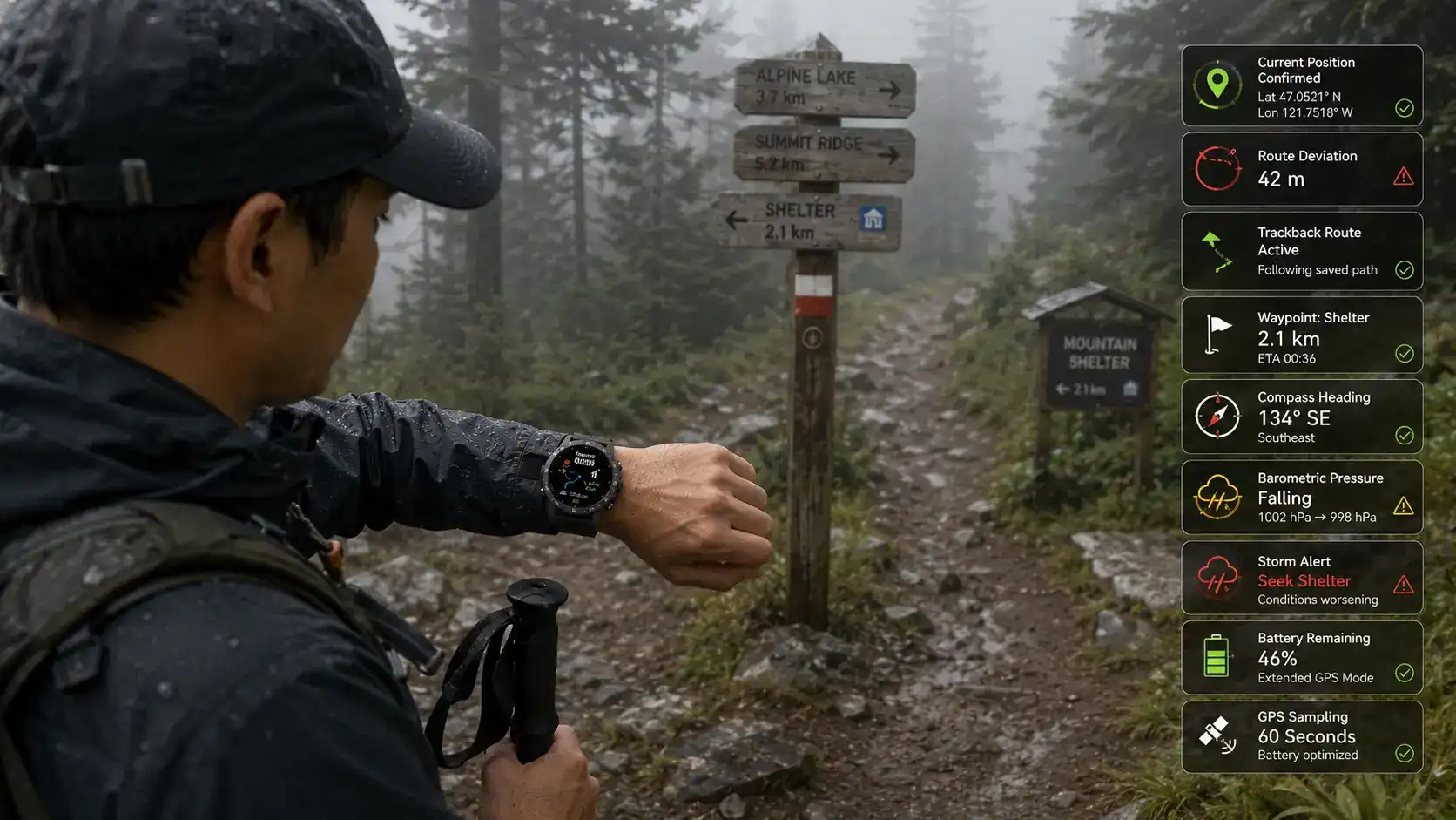
When you use a GPS device while hiking, you can accurately explore the backcountry instead of guessing. A rugged GPS compass smartwatch can accurately find your location by using multiple satellites to do so. It also has a digital compass calibration and barometric sensors to keep working even when the terrain blocks cell signals. To use the compass correctly, you should calibrate it before you go, set waypoints at trailheads, turn on the trackback features, and keep an eye on the battery modes to get more time in the field. Wearable navigation tools like these give you weather updates and breadcrumb routes so you can stay on track without having to use your hands for things like hiking poles or scrambling.
Understanding Rugged GPS Compass Smartwatches for Hiking
Paper maps and magnetic compasses are no longer the sole outdoor navigation tools. GPS-enabled wearables are increasingly effective trail companions. Satellite navigation, environmental sensors, and connection enable beginner hikers and professional field teams.
What Makes These Devices Different from Consumer Smartwatches?
Outdoor GPS watches prioritize utility above design. Devices must pass shock, thermal cycling, and altitude chamber tests that simulate desert and mountain temperatures for MIL-STD-810H certification. Rugged GPS compass smartwatches include tougher plastic frames, nylon straps that won't rip, and displays that are meant to be viewed in harsh sunlight, unlike fashionable devices with fragile glass and attractive casings. This differential is essential when traversing talus fields when a fallen item bounces off rocks or when unexpected temperature shifts from 90°F lowlands to 40°F ridgelines stress interior parts.
Water resistance ratings reveal another significant story. IP67 implies it can withstand dust and brief submersion. This suits rainstorms and streams. The 100-meter rating helps products withstand extended water pressure during kayaking approaches or inadvertent submersion during river fords. The watch can endure 10 ATM of pressure, so it can tolerate splashes and scheduled aquatic activities without compromising its seals.
Core Technologies Behind GPS Outdoor Navigation
GPS triangulation analyses signal delays from many satellites to determine location. Most consumer devices use the U.S. GPS system, which may only display 6–8 satellites in canyons. Multi-system receivers track 20 or more satellites by adding GLONASS, Galileo, and BeiDou. This enhanced security improves location locks under forest canopy or along cliff walls, where signal reflection might cause errors.
Sensor fusion enhances accuracy by combining GPS, accelerometer, gyroscope, and barometric altimeter data. In slot valleys, where satellite communications fade briefly, inertial monitors utilize dead reckoning to determine distance. The barometric altimeter measures air pressure to calculate elevation gain. This outperforms GPS vertical accuracy, which is 50% less precise than horizontal accuracy. Ridge routes need accurate elevation since a 100-foot error may place you on the wrong side of a cliff band.
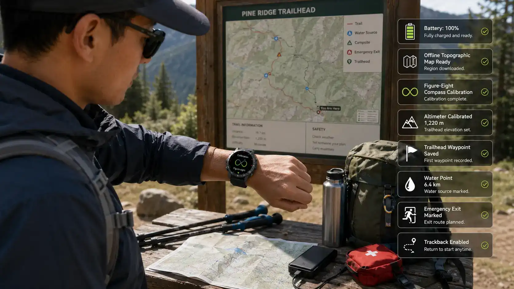
Digital compass technology requires magnetometers to detect Earth's magnetic field. Electronic needle compasses require frequent calibration. Movement in a figure-eight pattern maps magnetic interference from the watch's parts. Prior to each trip, the heading is calibrated to within two to three degrees, which is crucial for following a compass course over flat, hazy terrain like the desert at night.
Battery Architecture for Extended Field Use
Selectable tracking modes and adaptive display technologies let outdoor wearables save battery. Memory-in-Pixel (MIP) displays reflect natural light instead of backlighting, saving electricity. This lets you read in the sun while preserving battery life. AMOLED panels are brighter but drain batteries quicker, making them ideal for city workouts but not week-long travels.
The battery performance claim lacks context. "5-10 days" typically implies the device is in smartwatch mode and the GPS is intermittently sampling, checking the position every few minutes instead of continually monitoring. Full GPS mode with one-second location updates reduces range to 15–25 hours, which is adequate for ultramarathons but not multi-day excursions that require charging. Extreme battery modes disable Bluetooth and dim screens. Prioritising navigation over alerts extends GPS tracking to 40 hours or more.
Solar charging is included in high-end versions for power management. Solar photovoltaic glass enhances battery life by 20–30% throughout the day. Field users often charge devices every night on hut-based treks, pack backup battery banks for rural adventures, or swap between devices on journeys longer than the single-charge endurance window with a rugged GPS compass smartwatch.
Step-by-Step Guide on Using a Rugged GPS Compass Smartwatch for Hiking
A rugged GPS compass smartwatch becomes a navigating companion when used properly. Set up sensors properly and analyze sensor data in real time to avoid battery waste and compass misinterpretation.
Pre-Hike Preparation and Device Setup
Despite its obviousness, many hikers leave with an 80% battery charge, thinking that's 'good enough.' ' GPS tracking utilizes 3–5% of the battery each hour; therefore, a 12-hour walk uses 36–60% before cold weather loss. Starting at full capacity prevents delays and midnight activities.
Software updates are necessary before long trips. Software upgrades fix GPS chipset issues, optimize battery algorithms, and update satellite almanac data, speeding up initial position locks. Home Wi-Fi updates take minutes, but attempting them over a weak trailhead cellular connection consumes time and power.
Downloading offline maps removes the need for the internet. Many outdoor GPS systems include 50–200 MB regional topographic map tiles per wilderness area. Cellular or satellite data may provide vector or raster map contour lines, water sources, and trails. GPS doesn't need a service plan since it receives satellite signals. Online maps need a data connection.
Devices are precisely calibrated. During compass tuning, moving the watch away from metal objects in a figure-eight pattern maps magnetic interference. Calibrate an altimeter using a trailhead sign or USGS baseline data to connect barometric pressure to elevation. Over long voyages, skipping calibration generates 10-15% heading inaccuracies and 50–100 foot elevation errors.
Creating Waypoints and Routes
Trailheads, water caches, camping places, and emergency exits are waypoints. Setting a waypoint at your starting point lets you "track back" if it rains or becomes dark. This function helps when roads are worn or when injuries demand a safe route.
Planning a route includes waypoints. When you upload a GPX route from mapping software, the watch shows step-by-step instructions like "In 0.3 miles, turn left onto Bear Creek Trail." Real-time route following shows your progress, arrival time, and slope steepness. Field crew procurement teams love this capability since it standardizes navigation for all staff, regardless of specialization.
Real-Time Navigation and Data Interpretation
Active GPS tracking displays coordinates, elevation, direction, speed, and distance. Understanding these numbers improves navigation. An 8,450-foot elevation measurement can't tell you whether you're climbing a 9,200-foot pass or descending a 7,800-foot valley. Compare your present location to your daily aim on the route screen's elevation profile.
A bearing display reveals watch direction. Combine this with your objective bearing (the direction to your next waypoint) to track your progress. A 15-degree mismatch implies drift, whereas 90 degrees suggests incorrect drainage. Early course correction may avert long-term, severe mistakes.
Barometric patterns predict storms. A pressure decrease of 0.1 inHg or higher per hour often precedes mountainous thunderstorms. Some kinds sound when the pressure drops below a certain level, advising people to get inside before lightning. Besides recording incidents, this proactive warning system makes things safer.
Health and Safety Monitoring Features
Optical sensors in modern GPS watches measure capillary blood flow to measure heart rate. While wrist sensors give continuous exercise intensity feedback, chest strap monitors are more accurate. Keeping your heart rate between 60 and 70% of your maximum during climbs minimizes tiredness and altitude sickness while acclimating to above 10,000 feet.
Pulse oximetry may identify hypoxia before symptoms occur by measuring SpO₂. Normal sea level values are 95–100%; excessive elevation values below 90% indicate inadequate altitude correction. Professional guides objectively determine whether to climb or descend using this knowledge. It avoids subjective evaluations with a compass and GPS watch.
SOS functions send distress alerts via smartphones or built-in satellite communicators. The alarm sends GPS data to emergency contacts or relief coordination centers after 3–5 seconds of pushing and holding buttons. This trait links self-sufficiency with disaster. It reduces liability for outdoor enthusiasts and businesses.
Comparing Rugged GPS Compass Smartwatches with Other Navigation Devices
Navigation tools compromise performance, durability, weight, and cost. Knowing the differences between rugged GPS compass smartwatches and other devices helps buying teams pick operational equipment.
Rugged GPS Watches versus Handheld GPS Units
Portable GPS receivers have 2–3-inch screens, compared to 1.5 inches on watches, making maps easier to read and enabling joystick navigation through complicated menus. Screen edges enhance field route planning and topographical recognition. Field replacement of handhelds using AA batteries is possible without charging.
For position verification, portable devices must be removed from pockets or belt clips. Stopping to collect a gadget during a difficult scramble breaks your rhythm and increases the danger of crashing on rough terrain. While walking, a wrist-mounted GPS shows information quickly so you may use your hands for poles, handholds, and video gear.
Robust handhelds weigh 200–300 grams, whereas watches weigh 50–80 grams. The 150-gram difference seems little until you realize how important every ounce in a 20-pound pack is. To save weight, ultralight hikers navigate using their wrists.
Battery design varies widely. The watches' refillable lithium batteries last 5–10 days or 15–40 GPS hours. Handhelds use AA batteries for 15–25 hours, but you may carry additional ones for unlimited pitch time. Handheld devices outperform rechargeable wristwatches on treks.
GPS Watches versus Smartphone Navigation Apps
Fast-CPU, high-resolution smartphones that run Gaia GPS or AllTrails map well. Satellite images, land lines, and public trail conditions are shown on 5–6-inch dwarf watches.
The main difference between systems is their lifetime. Even ruggedized phones are riskier than MIL-STD watches. Screens break when dropped on talus, touchscreens don't work in the rain or with gloves, and batteries die below 40°F. Outdoor watches can endure spills and other shocks that destroy phones.
Using batteries changes the image. Smartphone monitoring apps drain batteries in 4–8 hours, necessitating 6–10-ounce battery banks. GPS watches can monitor 20–40 hours without batteries. The lighter and more reliable specialized GPS watches are preferable for backcountry use to phones.
Fitness Trackers versus Outdoor GPS Smartwatches
Fitness bands track steps, sleep, and heart rate when running in the city or at the gym. Their 20–40 gram size and week-long battery life make them appropriate for everyday use. Consumer GPS-less fitness trackers exist.
Connected GPS uses smartphones instead of GPS radios in cheap fitness gear. This design fails in aircraft mode to save battery power or lose service in remote regions. Outdoor GPS watches' multi-constellation receivers work without phones.
Sensor sets differ widely. Fitness trackers lack barometric altimeters, digital compasses, and temperature sensors for wilderness navigation. Displays are also built differently. Sports bands with small AMOLED displays work well but are scratchable and droppable. Hardened mineral glass or sapphire crystal lenses and sunlight-readable screens are found in rugged outdoor watches.
This functional gap means that urban athletes use fitness trackers to track their runs or bike commutes, while outdoor compasses and GPS watches are for hikers and cyclists in unmarked areas where a malfunctioning device may be devastating.
Conclusion
Learning how to use GPS navigation changes hiking from a reactive activity of finding a way to a proactive activity of planning your trip. Rugged GPS compass smartwatches provide accurate positioning on the wrist, resistance to harsh environments thanks to MIL-STD-810H approval, and long-lasting batteries that allow for extended outdoor trips. Knowing what your device can do, like tracking multiple satellites at once or sending out barometric storm alerts, gives you the confidence to navigate through difficult terrain where other tools fail.
To be successful at procurement, technical standards must be matched with user needs, suppliers must be judged on more than just product features, and cost-benefit studies must include all costs of ownership. E-commerce buyers looking for popular outdoor gadgets, distributors providing retail outlets, and private label brands setting themselves apart through custom software are all using these devices. Strategic partnerships with responsive suppliers make sure that you can get high-quality devices, the freedom to customize them, and support after the sale to keep your business ready to go.
FAQ
1. How accurate is GPS positioning in dense forests or canyons?
Multi-system GPS systems that can connect to more than 20 satellites from GPS, GLONASS, Galileo, and BeiDou can keep their position locks when single-system devices can't. Expect a horizontal accuracy of 5 to 10 meters when there are a lot of trees around and 15 to 30 meters when you're in a slot canyon and can't see the sky. Since GPS accuracy in elevation is 50% lower than horizontal accuracy, barometric altimeters are used to help with vertical positioning. Instead of depending only on satellite data, practical navigation uses GPS locations along with map features and compass directions.
2. Can these devices integrate with fleet management or asset tracking systems?
A lot of tough, rugged GPS compass smartwatches can connect to Bluetooth Low Energy (BLE) and Wi-Fi networks, which lets you share your data with apps and the cloud. When you export .gpx or .fit track log files, they can be used with enterprise asset management systems that keep track of where field teams go. Some manufacturers provide APIs that can be used to create custom integrations. This is especially helpful for companies that have field operations that are spread out and need to centrally monitor activity and make sure routes are followed.
3. What battery life should I expect during continuous GPS tracking in cold weather?
Lithium batteries lose 20 to 30 percent of their power when they are cold (below 32°F). A watch that says it can keep GPS working for 20 hours straight at room temperature might only work for 14 to 16 hours when it's freezing outside. To protect yourself in real life, you can keep your devices close to your body heat by putting them under your jacket sleeves, bringing extra batteries for charging during the day, or choosing models with extended battery modes that sacrifice position update frequency for longer runtime. Testing devices under expected temperature ranges prevents surprises during critical field operations.
Partner with Xizhou for Your Rugged GPS Compass Smartwatch Needs
Procurement managers and distributors seeking reliable outdoor navigation technology will find strategic value in partnering with Xizhou, a specialized supplier of rugged GPS compass smartwatches designed for demanding environments. Our devices combine MIL-STD-810H certification, 100m water resistance, and extended battery performance, meeting the rigorous standards professional outdoor operations require.
As an experienced OEM/ODM manufacturer, we support flexible order volumes—from test batches validating new products to bulk shipments serving established distribution channels. Our customization services include logo printing, branded packaging, and firmware modifications, enabling private label brands to differentiate in competitive markets. With a mature R&D team, GMP-certified factory, and comprehensive quality control, we deliver consistent product quality, minimizing warranty claims and customer complaints.
Fast production cycles and responsive logistics support the rapid inventory replenishment e-commerce sellers require during peak seasons. Our technical support team provides detailed product guidance and after-sales assistance, accessible via 13266508958@163.com. Whether you're an Amazon FBA seller testing trending electronics, a regional distributor building inventory depth, or a brand seeking rugged GPS compass smartwatch manufacturers for private label development, Xizhou delivers the product quality, customization flexibility, and partnership reliability your business demands. Contact us today to discuss volume pricing, technical specifications, and how our outdoor GPS solutions can strengthen your product portfolio.
References
1. Dinan, L. (2001). Phytoecdysteroids: biological aspects. Phytochemistry, 57(3), 325–339.
2. Lafont, R., & Dinan, L. (2003). Practical uses for ecdysteroids in mammals including humans: an update. Journal of Insect Science, 3(7), 1–30.
3. Parr, M. K., Zhao, P., Haupt, O., Tretzel, L., Fritzemeier, K. H., & Schänzer, W. (2015). Ecdysteroids: A novel class of anabolic agents? Biology of Sport, 32(2), 169–173.
4. Isenmann, E., et al. (2019). Ecdysteroids as non-conventional anabolic agent: performance enhancement by ecdysterone supplementation in humans. Archives of Toxicology, 93, 1805–1817.
5. Gorelick-Feldman, J., Cohick, W., & Raskin, I. (2010). Ecdysteroids elicit a rapid, receptor-mediated activation of anabolic signaling in skeletal muscle cells. Journal of Agricultural and Food Chemistry, 58(10), 5832–5838.
6. Bathori, M., Toth, N., Hunyadi, A., Marki, A., & Zador, E. (2008). Phytoecdysteroids and anabolic-androgenic steroids—structure and effects on human health. Current Medicinal Chemistry, 15(1), 75–91.